ALERT For Downpours Of Heavy Rain During The Predawn-Early Morning Hours Of Wednesday
The Storm Prediction Center Has A Marginal Risk Of Severe Thunderstorms Across The Entire Region For Wednesday and Thursday
An Upgrade To A Higher Level Of Risk Will Be Possible For Portions Of The Region. Stay Tuned For Updates.
Overnight Into Tuesday Morning
Mostly cloudy. Mild. Chance of a rain shower. SSE-SSW winds 5-10 mph, with some higher gusts, along mountain ridges & plateaus below 2700 feet. SSW-SW winds 5-15 mph, with higher gusts, along mountain ridges above 2700 feet. Temperatures widespread in the 50s to low-mid 60s.
Tuesday Afternoon
Partly-mostly cloudy. Chance of showers & thunderstorms. Some storms could be strong to locally severe, especially late. S to SW winds 5-15 mph, with higher gusts. Temps varying from 60s in upper elevations to mid-upper 70s.
Overnight Into Wednesday Morning
Showers & thunderstorms. Some storms could be strong to locally severe. Downpours of heavy rainfall likely. SSW-SW winds 5 to 15 mph, with higher gusts, along mountain ridges-plateaus below 2700 feet. SW winds 10-20 mph, with higher gusts, along mountain ridges above 2700 feet. Mild with temperatures in the 50s to lower-middle 60s.
At least a marginal risk for strong to locally severe thunderstorms will continue Wednesday and Thursday, amid many dry hours. Remain alert for the potential of strong-severe thunderstorm development.
Wednesday Afternoon
Warm & humid. A chance of showers & thunderstorms. Winds SW-W at 5-15 mph. Temperatures varying from the 60s to around 70 degrees in upper elevations to the upper 70s to lower 80s.
Wednesday Night Into Thursday Morning
A chance of showers & thunderstorms. Winds SW-WSW 5-15 mph along mountain ridges-plateaus below 2700 feet. WSW to WNW winds 5-15 mph, with higher gusts, along mountain ridges above 2700 feet. Temperatures in the 50s to low-mid 60s.
Thursday Afternoon-Evening
A chance of showers & thunderstorms. Some storms could be strong to locally severe. Warm & humid. S-SW winds mainly under 10 mph ( outside of storms ). Temperatures varying from upper 60s to lower 70s in upper elevations to the upper 70s to lower 80s ( warmest at lower elevations in the Russell Fork-Levisa Fork basins ).
Weather Discussion ( May 8-12 )
Tuesday Evening Update
A very active afternoon-early evening to the west of the mountains has resulted in Severe Thunderstorm Watch Number 163 being issued up to the Virginia-Kentucky line.
Severe Thunderstorm Watch In Effect To 2:00 AM Wednesday – May 11, 2016SPC Severe Thunderstorm Watch Discussion
A line of thunderstorms is likely to impact counties along the Virginia-Kentucky border after midnight, except for northern portions of Dickenson-Buchanan counties where severe thunderstorms are possible earlier.
JKL Doppler At 10:08 PM Tuesday
Local development could occur in advance of such storms, as recently seen along and northeast of Pine Mountain ( with local development trying to get started in the High Knob Massif area ).
Regional Doppler Composite At 8:38 PM Tuesday – May 10, 2016
A total of 1.11″ of rain was recorded at the Upper Norton Reservoir with downpours associated with late evening thunderstorms that moved northeast across Powell Valley into the High Knob Massif during late Tuesday evening.
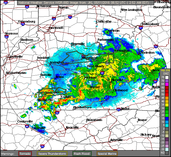
As of 2:00 AM Wednesday a non-severe line of thunderstorms, with heavy rainfall, was moving east across SE Kentucky and will impact the Cumberland Mountains overnight into Wednesday AM. Although downpours of heavy rainfall and lightning will remain most prominent, kinks ( bows ) in the approaching line continue to suggest localized strong-gusty winds will remain possible.
JKL Doppler At 2:52 AM Wednesday – May 11, 2016
Stay tuned to NOAA Weather Radio for possible additional watches and/or warnings which may be needed through Wednesday-Thursday.
Previous Discussion
Partly to mostly cloudy skies, with a little cooler temps, were observed on Mother’s Day which became better as the day progressed.
Late Spring Beauty In Powell Valley of High Knob Massif ( May 8 )
May 2016 has been wet, relative to March-April, with a stormy pattern expected to continue through much of this week before a break by late week into the early weekend gives way to another stormy period into next week.
*Cooler conditions are expected Friday-Saturday as a boundary stalls to the south, with return flow expected to then renew the threat for showers & thunderstorms by late weekend-early next week ( with a heavy rainfall potential ). Stay tuned for updates.
Storm Prediction Center Risk Regions To 8 AM Wednesday
The main focus Tuesday-Tuesday night will be on the potential for strong to severe thunderstorm development.
The SPC has expanded a slight risk region up against the western slopes of the Cumberland Mountains, with a noted potential for an upgrade to part of this slight risk region, to enhanced status, being possible by later Tuesday.
SPC Risk Of A Tornado Within 25 Miles Of A Given PointSPC Probability Of Damaging Winds Within 25 Miles Of A Given PointSPC Probability Of Damaging Hail Within 25 Miles Of A Given PointSPC Discussion For Tuesday into Tuesday Night
Rounds of showers and thunderstorms, some strong to locally severe, will remain possible Wednesday & Thursday in advance of a upper air trough and surface cold front.
Storm Prediction Center DAY 2 Risk Regions ( To 8 AM Thursday )
It is likely that the most favorable period for strong-severe thunderstorms during this mid-week time frame will come on Thursday as the surface front and trough approach from the west. Stay tuned for updates on this potential.
NAM 12 KM Model Total Rainfall Forecast Up To 8 AM Friday ( May 13 )
The NAM and GFS models illustrate how problematic it is trying to forecast rainfall at this time of year, with highly varied amounts over only short distances ( as the models guess where these MAXS and MINS will be, note that the key word being GUESS ).
GFS Model Total Rainfall Forecast Up To 8 AM Friday ( May 13 )
If the late week cold front stalls south of the mountain area, as currently suggested by the European Model group, then the potential for a heavy to excessive rainfall event may arise by next week ( with rainfall this week becoming a factor in the ultimate risk ).
*During May 1-9 more rain has fallen in Clintwood ( 2.43″ ) than fell during all of March ( 1.54″ ) or April ( 2.11″ ). It seems likely May will soon produce more rain than March-April combined.
Superintendent Gary Hampton, of the Big Stone Gap WP, reported the greatest April rainfall in the area with 4.64″ measured at the Big Cherry Lake Dam in the High Knob Massif ( 6.82″ during March-April and 22.28″ during January 1-April 30 ).